Lost in the River Bottoms
5 people located
RAPIDSOS location information and text communication
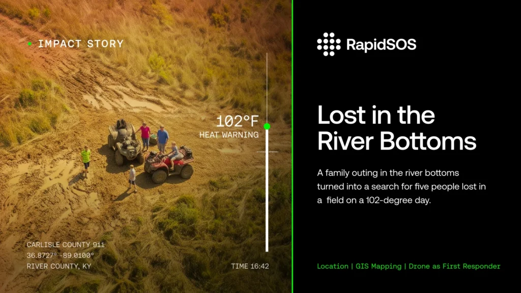
A family outing in the river bottoms turned into a search for five people lost in a field on a 102-degree day.
A husband and wife had taken their three children, all under the age of 10, riding in an ATV park near the Mississippi River. Their vehicle became stuck in the mud and suffered a blown tire, leaving them unable to ride out.
The family decided to walk.
According to River County 911 Director Larry Fraser, the distance from the river bottoms to a main road was not particularly far. But as the family walked, they began to realize they weren’t making much progress. The husband thought he knew a shortcut, and the family headed across open fields and cornfields.
They wandered for nearly three hours.
With temperatures reaching 102 degrees, the wife eventually made the decision to call 911.
At River County 911, telecommunicators Logan Hicks and Kandi Carter received the call. RapidSOS provided the caller’s location, but what appeared on the map initially seemed unusual.
The family was showing up in the middle of a field.
“The 911 came in, RapidSOS picked it up, and it showed them in the middle of a field.”
The telecommunicators began talking with the callers to understand how they had gotten there. Logan remained on the phone with the family throughout the response while the team used location information from RapidSOS and their ESRI maps to narrow down where they were.
They also used RapidSOS to text the family and asked them to send a photo of something in their surroundings that might provide additional context.
The photo that came back was of a tree.
There wasn’t an obvious landmark or road sign to guide responders in. But the location data was giving the communications center something much more actionable: an area where resources could begin looking.
River County 911 began coordinating a multi-agency response, bringing together Carlisle County Emergency Management, Carlisle County EMS, and the Carlisle County Sheriff’s Department. EMS and emergency management responded to the area, with emergency management deploying a sophisticated drone equipped with infrared capabilities.
Using the location provided to 911, the drone team began searching the area.
They found the family.
Logan was still communicating with them when the drone reached their location.
“Dispatcher kept talking to them, said, ‘Look up, do you see our drone?’ They said, ‘Yes, it’s just about 10 feet from us.’”
With the drone positioned above the family, deputies began making their way in on foot. They were directed to follow the drone to the family’s location and then guide them back out.
The family had spent nearly three hours walking through fields in triple-digit heat. By the time responders reached them, Fraser said they were exhausted and dehydrated.
Deputies brought them to a truck, where EMS personnel were waiting with water. All five family members were brought to safety.
Fraser estimates that from the time the 911 call came in, multiple responding agencies were on scene, the family had been located, and the effort to walk them out was underway in less than 20 minutes.
For Fraser, who began his 911 career in Carlisle County in 1990, the incident also illustrates how dramatically the information available to telecommunicators has changed.
When he started, his center had no computers. Information was documented on paper, and a large roadmap hanging on the wall helped telecommunicators determine where callers and responders were.
Today, River County 911 serves Carlisle and Ballard counties as a centralized dispatch center. The agency recently transitioned to modernized 911 capabilities, and telecommunicators can use tools including RapidSOS and ESRI mapping to help locate callers.
For this particular family, that difference mattered.
If the only information available had been a caller’s best estimate that they were somewhere a mile or two from a particular road, Fraser believes responders would have faced a very different search.
“We’d have never thought to look in the middle of a cornfield to find them.”
Instead, the communications center had a location to work from. Telecommunicators used that information alongside their conversation with the family, mapping tools, text communication, and the resources available from responding agencies to coordinate the search.
“With the technology now, we was able to pinpoint them within feet of where they were and got resources to them,” Fraser said.
A location on a screen started the response. The people in the communications center and the field turned that information into action, coordinating across agencies until a drone was hovering above a family that had spent hours trying to find its way out.
And this time, the family didn’t have to find the road.
Responders found them.